Cadillac Mountain Summit Loop Trail
Map
Gallery
Quick Facts
| Difficulty | wheelchair |
| Trail Type | loop |
| Distance | 700 yards (650 meters) |
| Estimated Time | 15 mins |
| Surface Type | paved |
| Elevation Change | 69 feet (21 meters) |
| Features | coastal views |
| Trail Markers | none but easy to follow |
| Scenery Rating | must see |
| Maintenance Rating | well maintained |
| Cell Reception | strong |
| Dog Friendly | on a leash |
| Fees | park entrance |
From the Sign
From Sea to Shining Stars
Many expect the view from Acadia's highest mountain to be nothing short of majestic. But much of this scene is outside park boundaries. Partnerships and teamwork help expand beautiful views, day and night.
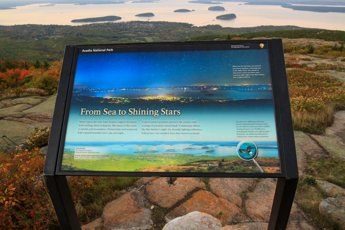
Conservation easements preserve the scenary and ecology of privately owned lands. Community efforts, like Bar Harbor's night-sky-friendly lighting ordinance, help protect star studded skys that stretch overhead.
Description
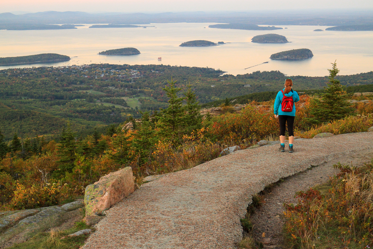
The trail is short but a great way to explore the peak area. It drops away from the peak towards the bay providing spectacular views. There are several interpretive signs that explain the landscape, geology and ecology of the mountain.

Note that since this is the highest peak in the park, and the highest peak along the eastern coast of the US, it is one of the busiest places in the park. This has caused the parking lot to be shut down several times in recent years due to overcrowding. Consider taking the park bus system (free of charge) to access the peak.
It is also the first place in the US to view the sunrise. If you don't like crowds avoid sunrise and sunset when this trail is busiest.
A great option for access is to hike up the mountain. There are several trails that climb to the peak from different directions.
Directions
For directions to the park go to the Acadia National Park page. Please consider using the free bus system in the park to assure you aren't driving around in circles trying to find a place to park. If you do use the buses make sure you plan your hikes so you don't miss the last bus of the day.
When in the park you will need to display a park pass. The best way to get a park pass is at the Sand Beach Entrance Station on the Park Loop Road. From Bar Harbor travel south on Route 3 (Main Street) for 1.7 miles (2.7 km) and then turn right into the park entrance. This short access road will take you to the Park Loop Road. Turn right onto this one-way road. Drive for 2.6 miles (4.2 km) and you will come to the Entrance Station. Buy a pass and continue to drive on the loop road. For more details on park fees go here. Make sure you enjoy all the spectacular views along the way.
Drive for 12.5 miles (20 km) on the Park Loop Road and then turn right towards Cadillac Mountain on the Cadillac Summit Road. Drive for 3.4 miles (5.5 km) on a very twisty, turny and steep road. At the end of the road you will come to Cadillac Summit parking lot. Note that this is one of the busiest places in the park and when the parking lot is full they close the road. The trail starts and ends on the outer edge of the circular parking lot.
If you already have a park pass you won't need to drive all the way around the Park Loop Road. Leave Bar Harbor on Eagle Lake Road (Route 233) and drive for 1.1 miles (1.8 km). Turn right into the Acadia Park entrance and at the top of the exit turn left on the Park Loop Road towards Cadillac Mountain. Drive for 1 mile (1.6 km) and then turn right onto the Cadillac Summit Road.
Other Trails in the Park
From the Sign
Not so Barren
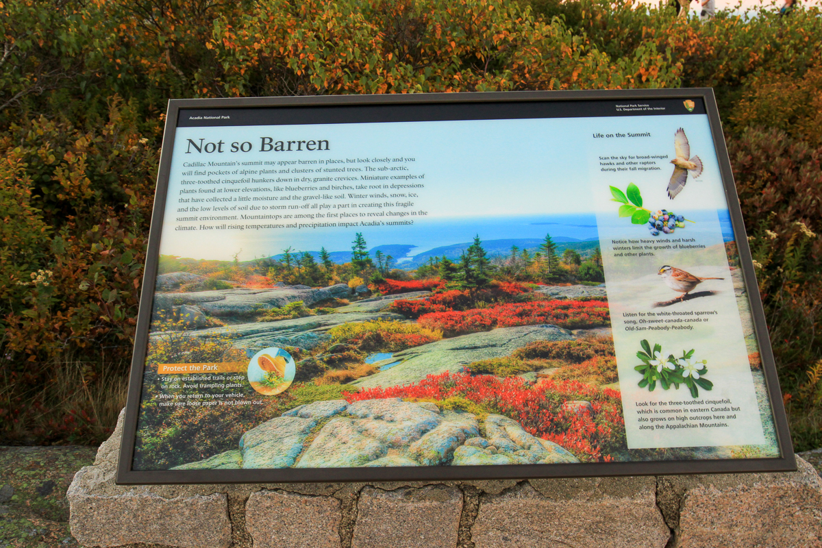
Cadillac Mountain's summit may appear barren in places, but look closely and you will find pockets of alpine plants and clusters of stunted trees. The sub-arctic, three-toothed cinquefoil hunkers down in dry, granite crevices. Miniature examples of plants found at lower elevations, like blueberries and birches, take root in depressions that have collected a little moisture and the gravel-like soil. Winter winds, snow, ice, and the low levels of soil due to storm run-off all play a part in creating this fragile summit environment. Mountaintops are among the first places to reveal changes in the climate. How will rising temperatures and precipitation impact Acadia's summits?

- Trail Last Hiked: October 7, 2016
- Page last updated: December 20, 2019