Knife Edge Trail
Gallery

Map
Quick Facts
| Difficulty | extreme |
| Trail Type | linear |
| Distance | 1.1 miles (1.7 km) |
| Estimated Time | 1.5 to 2 hrs one way |
| Surface Type | rock |
| Elevation Range | 551 feet (168 m) |
| Total Ascent | 748 feet (228 m) |
| Features | ridge, peak |
| Trail Markers | blue paint |
| Scenery Rating | must see |
| Maintenance Rating | well maintained |
| Cell Reception | variable |
| Dog Friendly | no |
| Fees | park entrance |
Description
The first time I crossed the Knife Edge we didn't know what we were getting into. It took us four hours to cross, mostly on our hands and knees, because we couldn't get our head around how high we were and how narrow the ridge was. This was the start of my hiking career. If you have any fear of heights don't cross this trail. If there is any kind of inclement weather happening or in the forecast don't cross this trail.

Now that I got some of the warnings out of the way I want to tell you that the risk is worth the reward. The trail provides non stop views to the lakes and the mountains to the south and down into Chimney Pond in Great Basin to the north. Also the views along the ridge to the peaks is phenomenal.
Starting at Pamola Peak the trail descends down into Chimney Notch. This is the most difficult part of the trail. Here you need to climb down a cliff face into the notch and back up the other side. The notch is just under 100 feet deep so it is no easy task and can be dangerous. Watch for rocks falling from other hikers and always face inwards. On my first trip I lowered myself down off a rock facing outward and my pack caught on the rock pushing me out over nothing. Luckily I caught myself bofore falling. Always make sure you follow closely the blue paint markers as they mark the easiest (and sometimes the only) route.

After climbing up out of the notch you will continue along the narrow ridge. After a section of flat open rock you will come to the second most dangerous part of the trail. The flat rock leads to a narrow ledge that continues to the right around a small peak. The easiest way around this peak is on the narrow ledge. The only problem is that the edge of the ledge drops off a couple thousand feet into the valley below. The rock is slanted slightly inward so lean into the rock, make sure you always have a good grip on something, and go slow.

Once you pass the ledge the trail continues along the ridge. There are narrow sections but none as exposed as the ledge. The trail is mostly a boulder scramble. The ridge undulates up and down but most of the ascent is closest to Baxter Peak. Here the trail widens out. If there was ever a trail where sturdy, high cut, hiking boots are required it's this one. On my last hike I went over on my ankle on a narrow piece of plated rock. The only thing that saves my ankle was hitting up against another plated rock next to it before going over completely. The upper part of my boot buffered the blow.
One more thing to watch out for is the wind. Sometimes when you step out from behind a boulder or ridgeline you will be stepping into a gust of wind (strong wind that you may never have experienced before). This can easily knock you off balance. A small fall here could turn into a big fall. Moral of the story is be careful and have fun.
You will want to cross the Knife Edge as part of a loop with other trails. This makes it difficult to do if you are climbing the mountain on one of the trails from the south (Abol or Hunt). There is no shuttle service in this park and it's a long walk around the mountain. If you did cross it and descend the mountain to Roaring Brook Campground you would be at least 13.4 miles away from your car by road.
From the Sign
MOUNT KATAHDIN
This tablet is placed here by the forest commissioner of Maine under order of the governor and exective council dated March 16, 1932 to record the gift and conveyance to the state on March 3, 1931 and October 7, 1931 by Percival Proctor Baxter, governor 1921-1925 of nine square miles of land in township 3 range 9 Mt. Katahdin, within which area are located this the highest peak of the mountain 5267 ft., named Baxter Peak by the state legislature laws of Maine 1931, south peak 5240 ft., Pamola Peak 4902 ft., the North Peaks 4734 ft. and 4612 ft., the Knife Edge, the Chimney, the tableland, Chimney Pond 2914 ft., Dry Pond 2799 ft., North West Plateau 4401ft., Harvey Ridge 4182 ft., Hamlin Peak 4751 ft., Rum Mountain 3361 ft. and the Great North and South Basins.
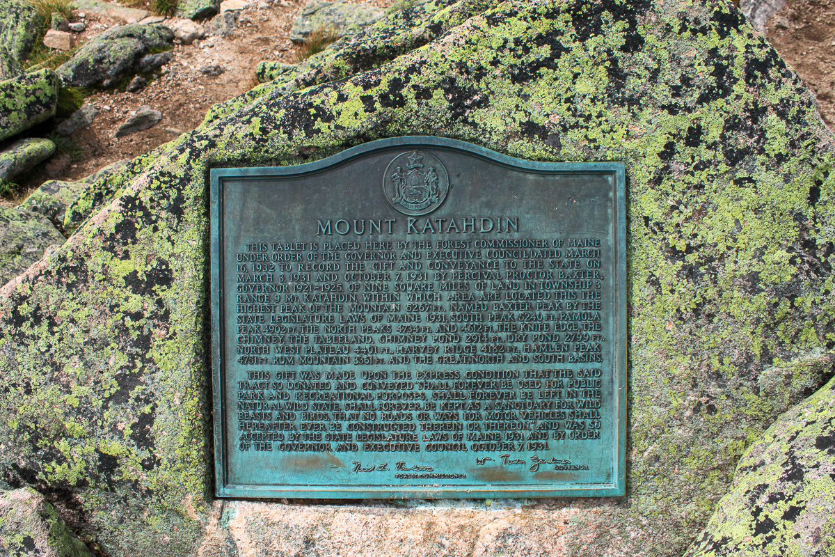
This gift was made upon the express condition that the said tract so donated and conveyed "Shall forever be used for public park and recreational purposes, shall forever be left in the natural wild state, shall forever be kept as a sanctuary for wild beasts and birds. That no roads or ways for motor vehicles shall hereafter ever be constructed therein or thereon." and was so accepted by the state legislature laws of Maine 1931 and by order of the governor and executive council October 7, 1931.
Directions
For directions to the park go to the Baxter State Park page.
This trail goes between Pamola Peak and Baxter Peak. You can access Pamola Peak (east end) on the Helon Taylor Trail or the Dudley Trail. You can access Baxter Peak (west end) on the Hunt Trail or the Saddle Trail.


Other Trails in the Park
- Abol Trail
- Cathedral Trail
- Chimney Pond Trail
- Doubletop Mountain Trail
- Dudley Trail
- Hamlin Ridge Trail
- Helon Taylor Trail
- Hunt Trail
- Marston Trail
- Mount Coe Trail
- North Basin Trail
- Northwest Basin Trail
- Saddle Trail
- Traveler Loop Trail
- Trail Last Hiked: September 20, 2015
- Page last updated: April 25, 2020